
When it comes to stunning natural wonders, Norway’s mountains and fjords just scratch the surface.
Regardless of which region you visit, Norway has lots of scenic surprises in store, from glaciers and ancient rock formations to waterfalls and wildlife. The following 15 hikes take in several of the country’s best natural wonders, including some with truly photo-worthy views.
Top Picks for You
Preikestolen
WHERE: Stavanger, Western Norway
You can’t visit Norwegian souvenir stores without seeing postcards that feature Preikestolen (Pulpit Rock). In fact, this formation has been used to market Norway for so long, that it’s now an international symbol of the country. Rightly so. From an elevation of more than 1,950 feet, Pulpit Rock offers a truly impressive view of the equally impressive Lysefjord.
INSIDER TIPAlthough it’s only 2.5-miles long, the path to this viewpoint is steep and rocky, making for a fairly challenging 2.5-hour hike. Wear suitable hiking shoes and leave your fear of heights at home—after all, the 82×82-foot plateau’s drop is not fenced off.
Kjerag
WHERE: Stavanger, Western Norway
Across the Lysefjord from Preikestolen, another stunning hike with postcard-perfect vistas awaits the fearless: that to the so-called Kjerag boulder. The viewpoint at this formation, which is essentially a piece of rock wedged between two mountainsides almost 3,300 feet above the fjord, offers just about enough space for two people at a time to snap a picture of the extraordinary view.
Indeed, the panorama from here is almost more impressive than that from Pulpit Rock across the way. What’s more, Kjerag is far less crowded than its sister formation—for good reason. Because the 3.2-mile trek here involves climbing and conquering bare rock, it isn’t suitable for novice hikers.
INSIDER TIPMake Lysebotn your base for a Kjerag adventure. The tiny village at the end of the Lysefjord has plenty of accommodations, including the very scenic Hauane B&B. If you stay here, ask the owners to show you the “cold cave” and the “king’s stone.”
Recommended Fodor’s Video
Trollpikken
WHERE: Egersund, Western Norway
In 2017, the Trollpikken (Troll’s Penis) formation gained international attention after being destroyed by vandals. The story had, excuse the pun, a happy ending, though: the local municipality of Egersund raised enough money through crowd-funding efforts to re-erect (again, excuse the pun) the rock.
The phallic formation is amid the Magma Geopark—a UNESCO-recognized landscape that was formed more than 900 million years ago from magma that was subsequently shaped by glaciers during the Ice Age. Although Trollpikken itself offers an extraordinary selfie opportunity, it’s the view of the surrounding landscape that has the greatest impact.
INSIDER TIPThe hike up to the rock only takes about an hour and is relatively easy, even for beginners. The steepest part is actually the gravel road from the parking lot to the trailhead; afterward, the terrain is rocky and a little hilly, but in good weather, it can be done in sneakers—no climbing required.
Trolltunga
WHERE: Odda, Western Norway
The hike to Trolltunga (Troll’s Tongue) is one of Norway’s most spectacular—and most challenging. At a total elevation of just over 3,600 feet, this formation sits almost 2,300 feet above Lake Ringedalsvatnet and has a drop that shouldn’t be underestimated; one young visitor has died here. Still, thousands of people safely conquer (and “conquer” really is the right word) the trail to Trolltunga each year.
The trek is best done in summer. Check the weather forecast before heading out, and get an early start. The almost 14-mile round-trip hike takes approximately 12 hours and requires navigating bare rock (which can be extremely slippery when wet) as well as marshland and streams. In addition to considerable hiking experience, the proper equipment and a day’s worth of provisions are vital to reaching Trolltunga safe and sound.
INSIDER TIPTrolltunga has two main parking areas. Try to snag a spot in the P3 lot (summer only) in Mågelitopp. Although it’s the more expensive of the two (600 NOK a day) and only has 30 spaces, it’s closer to the trailhead, and you can reserve a spot beforehand. The alternative P2 lot in Skjeggedal only costs 500 NOK a day but adds about 2.5 miles (along a steep road) to the hike.
Geirangerfjord
WHERE: Geiranger, Western Norway
One of Norway’s smallest fjords is also one of its most famous: the 9-mile-long Geirangerfjord, near the city of Ålesund, sees hundreds of cruise ships and thousands of visitors annually. What makes this UNESCO World Heritage site so impressive is that the surrounding mountains seem to rise almost straight up from the water. Geirangerfjord is also home to a series of cascades collectively known as the Seven Sisters Waterfall, with a drop of about 800 feet from the highest point.
The fjord has gained even more international attention since the release of The Wave, a movie documenting a frightful possibility: the collapse of nearby Åkerneset Mountain, which would cause a tsunami powerful enough to destroy the nearby village of Geiranger in just 10 minutes. Touch wood that this scenario is still just theoretical.
Sognefjord
WHERE: Sogn og Fjordane County, Western Norway
As Norway’s deepest (almost 4,300 feet) and longest (127 miles) fjord, Sognefjord is a must-see. Equally impressive is the fact that 12 other fjords branch off from it, including the well-known Nærøyfjord, a UNESCO World Heritage Site, and Aurlandsfjord, home to the scenic Flåm Railway.
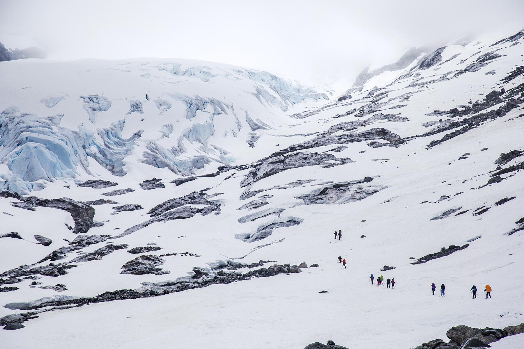
Svartisen
WHERE: Mo i Rana, Northern Norway
Although Svartisen is at the Arctic Circle, Norway’s second-largest glacier is very accessible thanks to its lower elevations. What was once a single large formation has separated into two parts, one to the west and the other to the east. Though the glacier is almost 5,300 feet above sea level at its highest point, it’s only 65 feet at its lowest point.
Summer and early fall are the best times to explore this glacier and its “black ice.” The color is actually a deep shade of blue, but in contrast to the surrounding whiteness of the snow, it sometimes looks black.
Jostedalsbreen
WHERE: Stryn, Western Norway
Jostedalsbreen is the biggest glacier not only in Norway, but also in continental Europe. It stretches across almost 200 square miles and has dozens of branches. One of the most popular is Briksdalsbreen, which is near Olden and is accessible on guided tours in “troll cars” (aka buggies). Accessing the glacier’s other branches requires hiking and ice-climbing.
Saltstraumen
WHERE: Bodø, Northern Norway
Saltstraumen, close to the city of Bodø, has the world’s strongest tidal current. Each day, during high and low tides, truly vast amounts of seawater are forced through the tiny, 492-foot-wide, roughly 2-mile-long strait separating mainland Norway from the island of Straumøya. The ocean rushes by at speeds of up to 25 mph, resulting in the creation of whirlpools that are as wide as 30 feet.
INSIDER TIPCheck the tidal timetable for Saltstraumen to ensure that you’ll get to see the watery show. If you’re lucky, your visit will coincide with a full moon, when tides are at their strongest.
Jotunheimen National Park
WHERE: Oppland, Eastern Norway
Jotunheimen National Park is a haven for hikers, climbers, and skiers. Its roughly 1,300 square miles encompass northern Europe’s greatest concentration of peaks over 6,500 feet, including 8,100-foot Galdhøppingen, Norway’s highest mountain. Grab your gear, and plan to spend a couple of days away from civilization in this stunning, quintessentially Norwegian wilderness.
INSIDER TIPA great base for exploring Jotunheimen is the little winter-sports village of Beitostølen. From here, you can go hiking or cross-country skiing on your own, or join rafting, horseback-riding, dog-sledding, and other guided tours.
Dovrefjell National Park
WHERE: Oppland, Eastern Norway
Together Dovre and Dovrefjell-Sunndalsfjella national parks cover some 770 square miles in southeastern Norway. The region is home to wild reindeer, as well as Norway’s only population of wild musk ox, which were imported from Greenland in the first half of the 20th century. Today, safaris take you to see these giants up close—which actually means from a safe distance of at least 225 yards.
Dovrefjell is also home to Mt. Snøhetta, which was believed to be Norway’s highest mountain until Jotunheimen (home to Mt. Galdhøppingen) was properly explored. Still, the 7,500-foot Snøhetta offers some great hikes and equally great views.
INSIDER TIPTrains travel from both Oslo and Trondheim to Dombås. This little town right in the center of the two national parks makes a great base for arranging guided hikes and musk-ox safaris, as well as ski- and snowshoe-adventures in winter.
Vettisfossen
WHERE: Årdal, Western Norway
The 900-foot Vettisfossen is Europe’s highest free-falling, unregulated waterfall. Situated in Jotunheimen National Park, Vettisfossen has been protected since the 1920s and is only accessible from Utladalen via a steep (it rises roughly 1,000 feet), 7.5-mile round-trip hike.
Gloppedalsura
WHERE: Stavanger, Western Norway
In the lunar-like landscape of Gloppedalsura, some of the boulders are as big as cars; others are the size of buildings. They’re all remnants of an ancient rockslide that’s thought to have been the largest in northern Europe.
At the end of the last Ice Age, more than 11,000 years ago, frost wedging (repeated freeze-thaw action) weakened the southern rock face of the mountain above Byrkjedal Valley, an hour’s drive from Stavanger. The resulting avalanche left this 330-foot-long stretch of scree at the end of a glacial moraine. Instead of rocks and pebbles, though, this scree consists of granite boulders. Because this granite was originally formed from magma, Gloppedalsura is also part of the Magma Geopark.
INSIDER TIPYou can easily combine a visit to Gloppedalsura with a hike to Månafossen–Rogaland County’s largest waterfall, which is just a 25-minute drive from the boulder field.
Hardangervidda
WHERE: Rjukan, Eastern Norway
At an average height of 3,600 feet, Hardangervidda is Europe’s largest (almost 3,300 square miles) high-altitude plateau. It’s also part of the biggest national park in the Nordic countries, stretching from Western to Eastern Norway across the three counties of Hordaland, Buskerud, and Telemark.
INSIDER TIPWhen visiting, you can stay in either Eidfjord or Rjukan. Both towns have a visitor center with information on the best trails and guided tours. Watch for reindeer during your trek: Hardangervidda is home to one of the world’s largest wild herds.
Marmorslottet
WHERE: Mo i Rana, Northern Norway
Not many visitors—yet, anyway—know about Marmorslottet (Marble Castle), but if you’re heading to Svartisen glacier, you should also check out this formation less than an hour from Mo i Rana. Over thousands of years, the river Glomåga has sculpted the rocks here into something of a natural art installation. What’s more, the water is a deep, icy blue—appropriate given its glacial origins.