One hundred years ago today the South Pole was reached by a party of Norwegian explorers under the command of Roald Amundsen. The existence of the pole had been known, but the inhospitable landscape presented a barrier until Amundsen’s party made the dangerous trek across ice and snow to stand at the geographical South Pole on this day a century ago.
One of Amundsen’s competitors, Robert Falcon Scott and his party, achieved a different kind of fame: they arrived on January 17, 1912 to find they were second in the race to fame, and they perished on their way back north.
News of Amundsen’s achievement was telegraphed to the world on March 7, 1912, on his return to Hobart, Australia.
On supporting science journalism
If you're enjoying this article, consider supporting our award-winning journalism by subscribing. By purchasing a subscription you are helping to ensure the future of impactful stories about the discoveries and ideas shaping our world today.
From Scientific American, Vol. CV1, No. 11, March 16, 1911
The Discovery of the South Pole
It is much too early to give any critical account of Capt. Roald Amundsen's achievement. Many weeks must elapse before we are in complete possession of all his data. Yet even the laconic account, which he has cabled to the press, throws a flood of light on the mystery of Antarctic geography. Amundsen seems to have collected enough evidence to substantiate the theory that the great chain of mountains which extends almost uninterruptedly from Alaska to Patagonia finds its continuation in a ridge connecting Victoria Land and King Edward VII Land, and which, in honor of his queen, he has named "Queen Maude's Range."
The ice barrier, which had proved for a century and a half a formidable obstacle to Antarctic exploration, is found to terminate in a bay, lying between the southeast mountain range running from South Victoria Land and a range which is probably a continuation of King Edward the VII Land and which extends in a southwesterly direction. Contrary to his original plan, Amundsen despatched one of his officers, Lieut. Prestud, to survey the Bay of Whales and the great ice barrier and to explore King Edward VII Land, of which practically nothing is known. No doubt the spur of competition played its part in unfolding the secrets of the last unexplored frigid region of the earth.
No less than four other expeditions were in the Antarctic regions at the time while Amundsen was forcing his way south. Besides Amundsen's, there was the Japanese expedition under Lieut. Shirase, which had to retreat to Australia last spring in order to replenish its supply of dogs, and which Amundsen says landed on January 16th at the Bay of Whales, two weeks before he sailed for home; Dr. Mawson's Australian expedition, for which $215,000 had been raised up to November 1st last, and which was to land three parties between Cape Adare and Gaussberg; the German expedition under Lieut. Filchner in the "Deutschland," elaborately equipped with wireless, magnetic, and meteorological apparatus, full of the hope of establishing a base southwest of Coats Land in as high a latitude as possible; and lastly, Capt. Scott's English expedition in the "Terra Nova," which left New Zealand in November, 1910, badly damaged by stormy weather; so badly, indeed, that the necessary repairs and the cost of making good the stores that had been lost seriously depleted the resources of the party.
Amundsen seems to have been helped by exceptionally favorable weather conditions. To be sure, there were storms, but not those frightful hurricanes which thwarted Shackleton. It was cold, so cold that the dogs suffered visibly; yet the average temperature was no lower than that in many an inhabited part of Canada. Amundsen himself states that part of his journey was much like a pleasure trip--"excellent ground, fine sledging, and an even temperature." The glaciers and crevasses make detours necessary, yet, despite them, progress was remarkably rapid. The party climbed up 2,000 to 5,000 feet in a day. Throughout much of his journey Amundsen covered entirely new ground. Therefore he will bring back absolutely new information of Antarctic geography. He made up his mind that he would reach the plateau on which the Pole is situated by another route than that of Beardmore Glacier. Luck, instinct, experience, call it what you will, the new route proved easier than that which either Shackleton or Scott took on their expeditions. To that comparatively easy route, coupled with exceptionally favorable weather, may be attributed Amundsen's success.
From Scientific American, Vol. CVI, No. 12, March 23, 1912
Amundsen's Attainment of the South Pole
Progress of Antarctic Exploration
By G. W. Littlehales, Hydrographic Office, United States Navy
The legendary limits of the Terra Australis of ancient and medieval cartographers, whose northerly coast was represented in art in the time of Ptolemy as extending eastward from Southern Africa toward China and inclosing the Indian Ocean, began to recede to the southward on the map of the world in the generation which produced Columbus, da Gama, and Magellan and disclosed America, the route to the Indies, and the circumnavigation of the globe. In the latter part of the sixteenth century the number of maps representing had noticeably lessened, and, by the end of the eighteenth century, it had faded from the minds of geographers.
The voyages of Cook in the latter part of the eighteenth century constituted the first circumnavigation of the south polar regions. He reached latitudes in some parts of his circuit which have even at the present time been scarcely surpassed, and, disproving the ancient beilef in a great Terra Australis Incognita extending northward of the sixtieth degree parallel of south latitude, the state of geographical knowledge such that the maps after his time mark "Antarctic Ocean" across the regions of the South Pole. The sum total or added knowledge in the sixty years following Cook's voyages had led to a general belief that around the South Pole was a scattered archipelago and not a continental mass, a state of geographical information that was not materially changed until the discovery by Charles Wilkes that after all there is a great Antarctic land, even if it is smaller than the land of legend.
It will be remembered that, during the year 1839, after having examined many of the island groups with which the vast area of the Pacific Ocean is studded, the United States Exploring Expedition, of which Wilkes was the commander, had reached the Australian shores. On the day after Christmas in 1889 the " Vincennes," "Peacock," "Porpoise," and "Flying Fish" headed southward from Sydney and, falling in with the land in latitude 64 degrees south and longitude 158 degrees East of Greenwich, on the 16th of January following, skirted the border of a new continent to the westward as far as longitude 97 degrees East of Greenwich. Returning to Sydney, Wilkes announced his discovery, in the following words, in a report to the Secretary of the Navy, dated March 11th, 1840: "It affords me much gratification to report that we have discovered a large body of land within the Antarctic Circle, which I have named the Antarctic Continent, and refer you to the report of our cruise and accompanying charts, enclosed herewith, for full information relative thereto."
At one or two points along this coast line, the French expedition under D’Urville, at nearly the same time, confirmed the existence of the land thus reported. Wilkes' work was not only important because he traced this coast for 1,700 miles, but also on account of the geological collections made by the expedition led by him, which showed that the land is formed of granite, massive sandstones, and other rocks of continental type, and further on account of the magnetic observations which were so numerous and well taken us to permit of the deduction of the earliest assigned position of the south magnetic pole.
A year later the extension of Wilkes Land to the eastward and the southward was charted by the famous British expedition under James Clark Ross, which discovered Victoria Land and the mountains of Erebus and Terror and surpassed all previous records in the Antarctic by reaching the latitude of 78 degrees. After the voyages of Wilkes and Ross, there was a long interval before serious work in the Antarctic was renewed. Until the close of the nineteenth century there was no part of the world about which less was known, and none about which so little interest was taken. This was probably due in part to its distance from the center of wealth and thought, and in part also to its dearth of animal and vegetable life and to its unpeopled state. It is only from the scientific side that human interest can he evoked in the desolate wastes of Antarctica. That this continent, whose present unexplored and unvisited extent is twice the area of Europe, was larger in former geological ages is scarcely to be doubted. In all probability it has been connected with Africa, South America, Australia, and New Zealand, although most likely not with all of them at the same time. This is suggested by the living and fossil floras and faunas of these lands.
At the time of the revival of Antarctic exploration in the beginning of the present century, knowledge of Antarctica was of two grades: in some areas the approaches from the sea had been explored; of the rest nothing was known, Knowledge of the first grade existed only in relation to two or three parts of the continent. They were Palmer Land with its associated islands, the coast of Victoria Land with the adjacent Ross Sea, and, to a lesser extent, the coast of Wilkes Land, The rest of the continental limits of the Antarctic was known only through the interpretation of imperfectly recorded observations and the speculations arising from distant and uncertain views.
The work of Krech, Gerlache, Borchgravink, and Bruce had not yet been done; the examinations of the “Belgica,” the “Francais,” and the “Pourquoi Pas” had not yet made known the extension of Palmer Land to the southwestward along the southern confines of the Pacific Ocean ; the explorations of the German Antarctic Expedition in the "Gauss" had not yet confirmed the conclusion of Wilkes that the long coast which he had discovered in 1840 extended still farther to the westward ; the Antarctic Continent had not yet been entered at any point and consequently that acquaintance with the general topography which constitutes the first essential to the scientific investigation of a country was wholly wanting,
It was the British National Antarctic Expedition of 1901 to 1904, under Capt. R. F. Scott, that first penetrated Antarctica. This expedition landed on the southwestern confines of the Ross Sea, and, by its explorations, showed that the great ice barrier is in reality the front of an enormous ice field or glacier, mainly floating on the surface of an extended bay or sea, and fed by glaciers coming down from the elevated land on the westerly side and probably also on the eastern. Scott traveled southward up the western margin of the ice field 400 miles to a point in latitude 82 deg. 16 min. 33 sec. south. He also climbed from his headquarters on MacMurdo Sound to the summit of the high table land to the westward.
Map of Amundsen’s journey, from Scientific American, Vol. CVI, No. 12, March 23, 1912.
CREDIT: SCIENTIFIC AMERICAN
Shackleton's expedition of 1907 to 1909 penetrated at the same place that Scott entered, and traveled up the western border of the ice field along the route which had been pursued by his predecessor until he reached a great glacier, named Beardmore Glacier, coming down from the highlands to the westward. He followed up this glacier to the summit of the plateau and then continued to the southward until he reached a point in latitude 88 deg. 23 min. south, only 97 miles from the South Pole. At this point the elevation was 10,000 feet above the level of the sea. While this journey to the southward was in progress, another party of the expedition climbed Mount Erebus, and a third party reached the south magnetic pole and located it, in 72 deg. 25 min. south, and 155 deg. 16 min. east, in a position 40 miles distant from the position deduced from the surrounding magnetic observations of the expedition under Scott. The observations in either case were not sufficient, however, to warrant drawing a conclusion as to the actual change in the position of the magnetic poled between 1903 and 1909.
Five expeditions were sent to the Antarctic during the past year, for the purpose of reaching the South Pole, or for the exploration of the Antarctic Continent, or both. The first is the British Expedition under the command of Capt, R. F. Scott, who was the leader of the British National Antarctic Expedition of 1901 to 1904. He sailed from Port Chalmers, New Zealand, in his ship, the "Terra Nova" November 29th, 1910. He made a successful landing at a point near his former situation in MacMurdo Sound, and continued to be engaged in exploration to the southward. A German expedition under Lieut. Wilhelm Filchner left early in the year 1911, intending to make a landing somewhere on the shore of the Weddell Sea, perhaps on Coats Land, on the opposite side of the Antarctic Continent from Capt. Scott’s headquarters. No reports have yet been received from him.
A Japanese expedition started for the Antarctic, intending to make a landing upon King Edwrd VII Land. Before reaching its projected landing place, however, this expedition suffered a series of mishaps, the chief of which was the loss of nearly all the dogs upon which relicance had been placed for transportation.
Near the close of the year 1911, another expedition started for it field of exploration in the Antarctic. This is the Australian expedition under the leadership of Dr. Douglas Mawson, geologist of the Shackleton expedition. The “Aurora,” a barkentine of 580 tons with auxiliary steam-propulsion in which the expedition sailed, has recently returned to Australia bringing the report that two separate parties have been landed on those part of Wilkes Land known respectively as Adelie Land and Termination Land.
Capt. Roald Amundsen, the discoverer of the Northwest Passage, left Norway in June, 1910, in the “Fram,” seemingly with the intention of sailing around Cape Horn, however, he sailed to the westward across the South Pacific, and made a landing at whale Bay on the ice sheet covering Ross Sea. This place is in King Edward VII. Land, near the eastern end of the ice front, and on the opposite shore of the Ross Sea, from the point at which Scott and Shackleton have made their successful entrances into the interior of the continent.
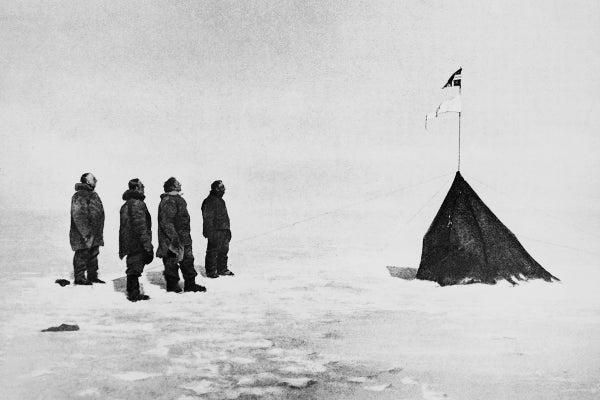
The expedition was in winter-quarters at Whale Bay until September, 1911, and, on the 20th of October. the main party made the final start for the South Pole, leaving a subsidiary party to carry on explorations and make a geological collection in King Edward VII Land. In less than a month. the south-bound expedition had cleared that vast plain of floating ice which flows down from the great mountains of the interior and covers the southern part of Ross Sea throughout an area above 20,000 square miles with an ice sheet approximately 800 feet in thickness, and had begun to climb the heights which form the mountainous embayment at the head of Ross Sea. The glacial streams descending through the depressions among the mountain slopes constituted the usual lines of travel, and the route developed was new and independent, passing among mountain peaks rising to the height of 15,000 and 18,000 feet above the sea and gradually mounting to a maximum level before the Pole was reached and thence descending very gradually for 140 miles over a vast plateau to the position which was occupied on December l5th and 16th, 1911, and determined to be the South Pole. As a result of Amundsen's expedition, important additions may be laid down upon the map of Antarctica in the sector of the earth’s surface extending from the South Pole to the 80th degree parallel of latitude between the meridians 160 degrees and 180 degrees west of Greenwich.
The theory of the structural unity of the Pacific is well established, and, according to it, the Pacific Ocean must be bounded on the south by a coast of the “Pacific type.” With one exception in Central America. the whole of the known coasts of the Pacific belong to this type. The main characteristic of this form of coast is that the trend is determined by mountain ranges running parallel to the shore. In the South Pacific, this type is well exemplified in New Zealand on one side and by the Andes of South America on the other. In the southern part of Patagonia the Andes are turned from their meridional course and run eastward across Tierra del Fuego. The tectonic line of the Andes is then apparently bent southward, and reappears in Palmer Land. It is probably continued around the southern Pacific meeting the end of the New Zealand line and the Victoria Range in the mighty mountains which Amundsen, in his approaches to the South Pole, discovered in the shape of what he has named the Maude Range stretching off to the southeastward as far as 88 degrees south. The principles of geomorphology would also suggest that from the lofty mountain axis bordering the Pacific there should slope downward, across the Pole, a broad plateau to Weddell Sea on the one side and the bight between Wilkes Land and Enderly Land on the other; and this interpretation is borne out by the description of the plateau conditions which were found to exist around the South Pole.
So far the facts published concerning the information gathered by Amundsen are chiefly geographical and topographical. and hence the illustration of the nature of the scientific hearings of the accessions to knowledge which his expedition has produced are drawn from these materials; but, as other branches of the information embraced in his observations are unfolded, other theoretical applications will appear for the advancement of philosophy and such of the geographical sciences as meteorology and terrestrial magnetism, concerning which the observations made in the South Polar regions tend in some respects to deliver the deciding stroke in the elaboration.