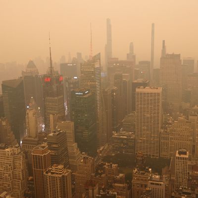
The air in New York City sucks right now, thanks to wildfire smoke from Ontario and Quebec that’s been trapped at near-ground level throughout the Northeast United States. Air quality has also plummeted to hazardous levels in western New York, and upstate looks like Mars.
With the sky turning an ominous sepia again on Wednesday afternoon, there was one question on our mind: When is this going to end? Bill Evans, the former meteorologist at WABC-TV in New York and the current owner and meteorologist at WLNG radio in Sag Harbor, explained why a rare combination of pressure systems has allowed smoke to hang over the Northeast — and why relief may arrive in a matter of days.
Why is this smoke lasting?
There’s a huge batch of smoke coming down right now from Canada that is coming out of Maine, New Hampshire, and Vermont. It’s swinging around a rather large cutoff low-pressure system, which is moving counterclockwise. A lot of things have to come into play to create this kind of situation, where the smoke is continually coming down from Canada.
What we have going on right now is called an Omega block. That is, you have a low that is in the Gulf of Maine to Nova Scotia, you have a big high-pressure ridge over Canada, southward across the central U.S., and you have a low-pressure system that is just off the coast of California west of Los Angeles. So the jet stream wraps around that — it comes around the base of the low out west, comes up northward into Canada around the big high-pressure ridge, then comes back around the bottom of the low that is in the Gulf of Maine. The jet stream looks like a giant Omega symbol: thus the Omega block.
And the key word is block. It blocks everything, this kind of setup. You have high pressure well out into the Atlantic that blocks the low from leaving and sort of backs it in a little bit toward the U.S. coast. So this low that is sitting there, it spins counterclockwise. The prevailing winds are out of the north and northwest. And the fires are up in central Ontario and Quebec and around Nova Scotia and so that low, the winds around that pull the smoke farther south.
How and when is it going to end?
What gets this to stop is the low-pressure system dissipating, weakening, and then the winds stop or change direction to push the smoke out into the Atlantic. And that’s what we’re expecting to happen as we go into Thursday and Friday. We’ll have more of a wind out of the north, and the low will be weakening and backing into Maine. Eventually, the system will go north into Canada on Thursday night and Friday. Saturday it will finally get out of here and take the smoke with it.
So we’re ultimately waiting on this low-pressure system to move out rather than waiting for the fires to be extinguished?
That’s right, it’s all dependent on this low that’s stuck there. Had it not been, you would have had high pressure coming in that would have pushed the smoke out into the Atlantic. But this pattern has everything kind of stuck in place.
It looks like there’s a break in the smoke coming behind this next batch coming in tonight. And it looks like we get a little break tomorrow, a northerly wind, but it’s a very light wind. And also, we’ve got a front coming down that might mean showers in parts of the Northeast, which would help knock some of the smoke particles down as well.
So the low-pressure system is also creating the conditions that allow the smoke to reach ground or near-ground levels? In recent years, when there have been fires in the west, we’ll get a hazy day, but it doesn’t feel like this.
That’s correct. Low pressure and high pressure, if you look at it dimensionally — the low is a valley and the high is a mountain. And the lower-pressure area is allowing the smoke to come down through the troposphere. Once it gets down to the surface, the surface winds take hold, and there’s been that wind consistently out of the north and northwest spinning around the low.
Why does it seem to be worse in the afternoon and early evening?
The heating of the sun fires up these particles and traps them at the surface. Fortunately, we haven’t had extremely hot air. If we had 90-to-100-degree temperatures, that’s the only thing that could have made this worse.
Is this what it was like in the ’60s smog era?
Back then, the pollution was from automobile emissions, industry, stuff like that, where you had cleaners, dry cleaners emitting into the atmosphere wildly without a lot of regulation. That would get heated up by the sun — you could actually see the dome over New York City. But now that the air quality has gotten better and there are more restrictions on pollutants going into the atmosphere, that’s gotten a lot better.
This interview has been edited for length and clarity.
Related
- The Wildfire Haze Is Coming Back to New York
- Canada Is on Fire. America Is Choking on Smoke. Is This the ‘New Abnormal’?
- Photos: Smoke Grinds City to a Halt With Relief in Sight


